
The Municipality of Naples (Comune di Napoli), Italy's third-largest metropolitan area, is a city faced with complex urban challenges, ranging from socio-economic disparities and climate change to overtourism and gaps in public services. Recognising the need to improve urban resilience, Naples sought to integrate data-driven strategies into its urban planning and mobility frameworks. Through a collaborative effort involving local expertise and European partnerships, the city has embarked on a data-centric journey, utilising the Big Data Test Infrastructure (BDTI) to create actionable insights for urban and environmental improvements.
Pilot objective
The primary objective of the Naples BDTI pilot is to enhance urban resilience and sustainability by leveraging data analytics to address climate change impacts, such as extreme heat and heavy rainfall, and improve public space utilisation. By integrating socio-environmental data and identifying high-risk areas, the project aims to support decision-making processes for urban planning, mobility, and public safety. The pilot also seeks to provide actionable insights into green capital metrics and socio-economic vulnerabilities, fostering a data-driven approach to urban management. Reflecting on the ongoing nature of the pilot, Francesca Pignataro, GIS Chief Analyst for the Comune di Napoli, commented: "Our aim is not only to analyse data but to create a culture of data-driven decision-making within the city administration."
Discovering the potential of BDTI
The Municipality of Naples’ journey with BDTI began through its participation in the BeOpen project, a European initiative aimed at fostering innovation across urban landscapes. As part of the Digital Europe Programme, BeOpen introduced Naples to the possibilities offered by the BDTI platform. With its comprehensive suite of tools and focus on big data applications, BDTI presented an ideal opportunity for the city to address its urban challenges through data analytics. Francesca elaborated, "Experimenting with BDTI tools gave us a unique opportunity to integrate datasets and visualise urban challenges, which is essential for developing actionable solutions."
The data
Geographic datasets serve as a crucial foundation for spatial analysis and decision-making, particularly when addressing urban planning and sustainability goals. The datasets the Naples team are using include public space data to analyse its distribution across administrative subdivisions, assess functionality, and identify underutilised areas or spaces with critical features that could be targeted for regeneration or redefined in the city's masterplan. Sustainable mobility data, structured and ready for sharing, provides actionable insights into transport patterns, enabling the development of greener and more efficient mobility systems. Heat exposure values and green index calculations, derived from the SPOTTED platform, offer crucial indicators for identifying areas prone to overheating and prioritising interventions to enhance urban liveability and environmental resilience. Statistical data further complements these datasets, enabling detailed analysis to guide evidence-based decisions that align with the project’s goals of fostering sustainable mobility and improving the quality of urban environments in Naples.
The framework powering Naples’ vision
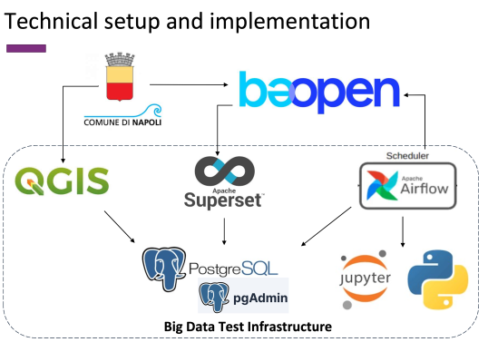
Naples’ implementation of BDTI relies on a carefully curated set of tools tailored to its urban planning objectives. Key tools include:
- QGIS for geospatial data integration and linking public space data with statistical information on population and vulnerable social groups. It also plays a crucial role in climate-related analyses and extracting green capital assessments from remotely sensed data.
- PostgreSQL is serving as the centralised database, storing datasets resulting from QGIS analyses and enabling efficient data retrieval for further processing.
- Apache Superset facilitates the creation of graphical visualisations and interactive dashboards to aid decision-making and dissemination of insights.
- Jupyter Notebooks provides a versatile environment for developing Python workflows, automating data cleaning, and integrating multiple datasets.
- Apache Airflow supports the automation of Extract, Transform, Load (ETL) processes, ensuring streamlined data workflows and efficient database integration.
The project team comprises a multidisciplinary group of GIS experts, planners, and external technological partners from the BeOpen initiative. Partners include European municipalities, competence centres, and startups specialising in ICT and Earth Observation technologies. Francesca notes the importance of collaboration: "The diversity of expertise within our team and among our partners has been instrumental in overcoming challenges and driving progress."
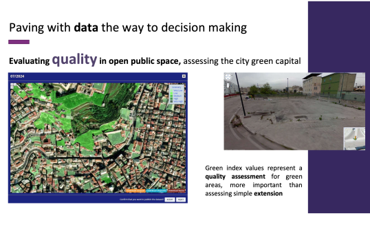
Strategic data integration with innovative tools
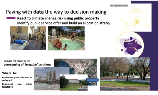
Naples is aiming to enhance its urban planning and mobility strategies by using data analytics to address the impacts of climate change, particularly extreme heat and heavy rainfall. A significant objective is to identify 'relief hubs' across the city—places where citizens can find protection during extreme weather events. The city is leveraging NDVI (Normalised Difference Vegetation Index) analysis to quantify green capital, an essential metric in mitigating urban heat island effects. Additionally, the municipality is linking geospatial data with social parameters such as family numbers and fragile populations, adopting a holistic approach to socio-environmental equity.
Using the BDTI platform, Naples is integrating datasets from multiple sources to address critical urban planning gaps. Public space distribution, green index values, and heat exposure assessments are being harmonised using cutting-edge tools such as QGIS for geospatial data, PostgreSQL for centralised storage, and Apache Superset for visualisation. Jupyter Notebooks and Apache Airflow are also being employed for efficient data processing and workflow automation.
Overcoming challenges and building resilience
With impressive goals comes the possibility of challenges. The team is facing and working to overcome some minor roadblocks, such as delays in receiving critical datasets and operational issues with tools like Mapbox in Superset, which require token configurations for geographic map displays. Despite these setbacks, the team is demonstrating resilience by actively collaborating with technological partners to find solutions and ensure the continuity of outputs from BDTI into the BeOpen project dashboard. Francesca reflected on these difficulties, saying, "Challenges such as delays and integration issues taught us the importance of flexibility and constant communication among team members."
Collaborative efforts and next steps
Collaboration plays a pivotal role in the project’s progress. Partners from the BeOpen project, including European municipalities and competence centres, provide the necessary technical and strategic support. These efforts will culminate in the development of advanced data visualisation dashboards, enabling policymakers to identify underutilised public spaces, assess socio-environmental vulnerabilities, and profile strategies for risk mitigation.
Preliminary insights are emerging, including identifying potential relief hubs and mapping areas requiring targeted interventions based on socio-environmental metrics. A critical lesson to date for Naples has been the value of assembling multidisciplinary teams and defining clear, manageable problem scopes. Additionally, the municipality’s experience highlights the importance of user-friendly onboarding materials for platforms like BDTI, which could help future projects overcome initial technical barriers more effectively. Francesca added, "One of our biggest takeaways is the necessity of having both domain experts and IT specialists working hand in hand to achieve meaningful results."
As Naples progresses, it aims to document its journey comprehensively, providing a showcase for other public entities to adopt similar approaches. By embracing data as a tool for public good, Naples is taking meaningful steps toward a more sustainable and resilient future.
Details
- Publication date
- 21 January 2025
- Author
- Directorate-General for Digital Services